| Index | Packing | Travelogue | Mechanical details | People | Tips |
This page is very disorganized now because I'm writing it on the road, but at least it works (if you're reading it). This year I suddenly realized I had the chance to combine an event in Lake Tahoe (the BMW Motorcycles 80th anniversary bash) with a major road trip. In two fast weeks I performed a lot of repairs to the bike and set off.
I'm breaking this down into parts, and trying to send out some trip reports from the road (when I have access, like at Ride West BMW in Seattle, Ricky's Restaurant in Whitehorse, a B&B in Talkeetna, Adam's house in Anchorage, and Carroll's house in Tok). As time goes on I may have the chance to re-write parts of it but for now I'm just posting everything I have, along with PhotoShop albums.
And while you're at it, check out the photo album of my traveling companion.
(pictures here)
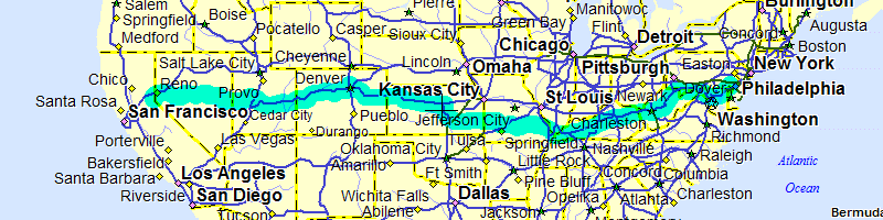
"Don't take US50 to Tahoe," said the girl at the motorsports dealer in Steamboat Springs, "It'll add 300 miles to the trip, it's poorly maintained and posted at 55mph and they enforce it strictly."
This was on top of the fact that I was already late due to their difficulty in changing my tire; I had 900 miles to go in the next 24 hours and it was going to get hotter. Fortunately, over the miles, I've developed a healthy skepticism for directions from locals and I checked the computer. "Nope - 40 miles longer if I go on the interstate.. I think I'll get into Utah and decide then." I knew full well I would take 50 because it was what I wanted to do - called "The Loneliest Road in America" I wanted to see just how desolate it was.
I had been on US40 all morning, coming from Denver. Monday I had just blasted 600 miles to Lexington KY, Tuesday I crossed the Mississippi at Paducah and then took back roads to Fort Scott Kansas, and the next day I'd suffered rain and delays in central KS and finally had a pretty tiring blast on I-70 into Denver, getting to my destination about 10:30. Today was going well, riding-wise, as I had taken US40 nearly from Denver, over some mountains and through ski towns. Time-wise it was a disaster, as it was afternoon and I'd only covered 170 miles. Pretty miles, though.
Armed with a fresh rear tire and a good lunch, I set off for Utah. I have a thing about taking one road as far as I can, so I stuck with US40 until Heber City, at which point I discovered that I had missed a turn-off and it would now be 40 miles closer to take the interstate. Not much of a dilemma, though: I turned south towards US50. After Provo and Orem, I got onto US6 at Spanish Fork and at Delta that hit US50. At last! A sign said "Next Services 86 miles" and it became immediately apparent that there was very little out here, besides the occasional ranch, between towns. And the towns were generally about 70 miles apart.
I find the desert to be really, really beautiful. Especially early and late in the day, with the sun at a low angle, the earth tones are vibrant and the shadows show the full scale of the landscape. At high noon, it could all be a painted backdrop with much less perspective. Leaving Delta the sun was just going down, the temperature was perfect, the air was still and the bike was running perfectly. When I stopped and turned the engine off, there was simply not a sound to be heard. Some stretches of highway went more than 20 miles without a curve, and when darkness fell headlights on oncoming cars could be seen 25 or 30 miles away. At crossroads, signs pointed to towns that were 12, 20, 45 miles off the highway and probably had only one street.
I needed to make up some time and I figured that nighttime in the desert was a good way to do it. At the Nevada state line (the services that were 86 miles away) I picked up some food and a drink, and packed them away for later. The next 70 miles took me Ely, and the next 70 would be Eureka but I pitched the tent about 10 miles before that and slept soundly. Continuing on to Eureka in the morning, there was no diner to be found so I did another 70 miles and got breakfast in Austin.
In addition to a town every 70 miles, the road crossed a small mountain range every 25 miles or so. At night, in the eastern part, the elevation went to 7500 with a noticeable temperature drop every time. In the western part they were lower but still brought a cooler breeze for a moment. When I pulled over for the night, I picked a spot where it wasn't too cold but the next morning was pretty chilly.
In the end, fortunately, the girl's ominous warnings were completely off-base. The road was in fantastic shape and posted at 70mph. Desolate? Yes, even the true locals consider it desolate but it was one of the most beautiful parts of the trip.
(pictures here)
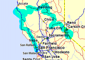
Leaving the Nevada desert, I was sort of sad that it was ending. Not only was it beautiful, but I was making really good time! Staying up until about 11:00 and then getting an early start had put me back on schedule, and I had a good chance of getting to the campground at noon, so I started frittering away the time immediately, stopping aat a great big sand dune and then trying to ride on the dry lake bed across the highway. But the real delays started once I reached Fallon, and civilization started again, complete with traffic lights and very heavy traffic. What a contrast to the early morning! The land around Fallon is irrigated, so there is agriculture as well as the industry that you'd expect that close to Carson City. Further west it gets more and more congested, so if you're making this trip, you might want to break for the interstate as soon as possible.
Near Carson City, great canyon roads took me up to Virginia City, then over the mountains into Steamboat Valley, then over another range to Lake Tahoe. Coming down towards Incline Village was a really neat moment; seeing the lake in front of me and then the "Welcome to California" sign really drove home the fact that I had made the first leg of the trip.
Sasha and Meredith arrived that evening, and the next four days consisted of attending activities at "the Bash" (BMW's 80th anniversary celebration) and touring the area. At the Bash, stunt performances by Jean-Pierre Goy (the stunt rider in "Tomorrow Never Dies") were amazing, and off-road seminars by Jimmy Lewis (he raced a BMW in the Paris-Dakar) were great. I even got used as a student in one of them! Our attendance also got us a pass to take the gondola up to Squaw Peak and lounge in the spa. Outside the bash, the fire road to Verdi Peak gave great views of the area from Reno down to Truckee, and Sunrise Pass was a wonderful and remote tour of the Nevada desert mountains. Not even shown on all maps, Sunrise Pass Road (all gravel, dirt and dust) runs from Wellington NV north and then west across some mountains and ends between Minden and Carson City.
The following week was a great tour of the northern Sierras and southern Cascades, and we rode west towards the central valley and then east again when it got too hot. Snow was still deep in Lassen Volcanic Park, and highways 299, 36, 3, and numerous fire roads offered great riding and spectavcular views of the Sierras. A fast evening blast down the Lost Coast showed the Pacific at its best, and the weather was just about perfect all the way. It was the 4th of July weekend, though, meaning that we'd get caught in some traffic in the more touristy areas, so we just avoided them where possible.
Back at Sasha's house I performed some long-overdue repairs to the bike, including a new fork seal, front tire, exhaust gaskets, oil change, front brake rebuild, swingarm dust boot, and maybe one or two other things. Everything but the tires and oil change were needed long before the trip started (I just didn't get to them when I was overhauling the engine top end before I left); the bike has been holding up very well since I started.
(pictures here)
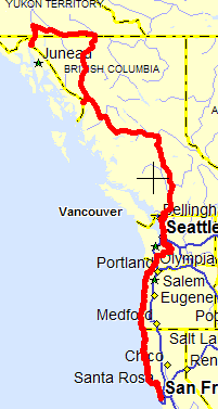
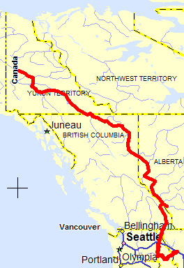
From San Franciso I went north on 101 for about 100 miles, then turned off onto Skaggs Spring Road. The first part of this rivals the Cherohala for quality of construction, but later it turns narrow and bumpy, which was fine also. With little warning, it dumps you out onto the Coastal Highway, with great views of the ocean. Where CA1 leaves the coast, I got onto a (technically closed) dirt road leading out to the lost coast and then up to the Redwoods. Then 1 again up the Oregon coast, and then cutting across the state to cross into Washington at Longview.
After a brief stint on I-5, smaller roads lead east to Mt. Rainier. I circled the mountain to the south in the evening, camped on the north side and then headed to Seattle. From there, I went up smaller roads to Silver Lake State Park, near the Canadian border.
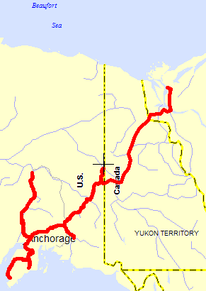
The next day I crossed at Sumas into British Columbia, then used BC1 and BC97 to head north to Quesnell where I spent that night. The next day I continued on to Prince George, then went west on the Yellowhead Highway until I reached the Cassiar.
About 100 miles up the Cassiar is the turnoff for Stewart and Hyder AK. I nearly stayed at a campground there, but decided I wanted to get into Alaska that day, and headed for Hyder. There isn't even a Customs gate going into Hyder!!! I met Jakita, Bud and Phil at the Sealaska campground and we spent the next few nights togeether working our way farther north.
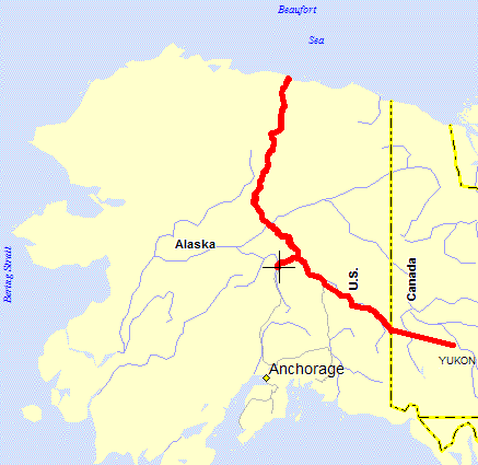
We took the Alaska Highway to Deadhorse, spent the night at Takhini Hot Springs and then headed south to Skagway.
(pictures here)
 (pictures
here)
(pictures
here)
After leaving Fairbanks the second time I headed south towards Denali and shortly afterward ran into the beginning of the August weather pattern, which is misting and irregular rain nearly every day. Leaving Denali, a couple on an FJ1200 zoomed by and I saw them that evening in Talkeetna. Jim and Stacey, from Vail, knew Tom, the guy I had ridden up the Dalton Highway with! They were on a somewhat shorter trip than I was, but still had time to check out most of the Alaska destinations that I was heading to before they took the ferry back south.
The next day, rain started in and I took shelter for a few days with Adam Verrier, an R100GSPD rider I had met at Coldfoot. It was pretty cool to be under cover for a few days, but when it became apparent that the weather wasn't clearing out any time soon I headed down to Seward (met Jim and Stacey again, going the other way) and Homer, went back to Seward for some hiking at the Exit Glacier (in the rain - yuk) and then dried out for another night at Adam's. From there, I headed east and found Carlo, who had been riding with Sarah and Rich, from New York. I had met Carlo on the Dalton, and seen him again at Seward with Sarah and Rich, so it wasn't surprising (given the few roads in Alaska) that I would find him again. We camped together under a powerline that night, somewhat alarmed by the sounds of branches breaking under the feet of some large animal but not worried enough to get up.
Then I split off and went down towards Valdez. The weather was iffy again, and I wanted to get to both Valdez and Kennicott. Shortly past the turnoff to Kennicott I met... yup, Jim and Stacey again, coming back and they reported poor weather down at Valdez. So, back towards McCarthy I went, Jim and Stacey went as far as Chitina before deciding that it didn't make sense to go further given their limited time left.
Kennicott and McCarthy were wonderful. I only spent a day there, hiking out to the glacier and up to the Bonanza mine, but I want to go back. Returning to Chitina that night, I camped by the river with Linda and Steven, who were fishing there. Going to Valdez the next day was just a bad idea... there was little to see, and it rained on me all the way back to Glenallen (100+ miles). After that I dried out, though, and met up with two riders from Minnesota (Andre and John) at a campground near Tok.
That was one of the last developed campgrounds I used on the trip. The next day, after stopping in at the house of BMW rider Carroll Johnson for some repairs, I went up to Eagle and then camped near the border in the wilderness. The next morning I went to Dawson City and then up the Dempster Highway as far as Eagle Plain, where I camped with two Frenchmen (from San Francisco) that I had met in Dawson. I reached Inuvik the following afternoon, ate a caribou burger and turned around - the ride was nicer than the town, although the town wasn't bad - and rode nearly back to Eagle Plains, stopping for the night in a screened-in picnic shelter that I had found on the way north. That was the longest day I'd had in a while; almost 500 miles but there was still plenty of light at 11:00 PM. By the next afternoon I was back on the Klondike Highway near Dawson City, ready to head south again.
 (pictures
here)
(pictures
here)
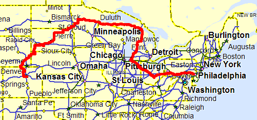
Only now did I begin to worry a bit about getting home on time, and started to somewhat plan the time. Really, I only wanted to get back to Missoula in time for the start of the Iron Butt Rally, but since I was only covering about 250 miles per day I needed to get serious. I ditched the idea of going to Yellowknife, and took the Campbell Highway (400 miles of gravel or so) east, miraculously finding a cookout that the town of Faro was hosting. Free food!!! All sorts of meat from various arctic animals, and great company as well. Faro also has a great museum and cheap camping (with free showers). Once the town center of the lead-zinc mine nearby, it has had to reinvent itself as a tourism and backcountry activity center when the mine closed.
The next day I made bigger miles, reaching my goal of Liard Hot Springs, a free (gotta love that word) hot spring park between Watson Lake and Dawson Creek. As I was walking to the springs, I started talking to a couple walking the same way, and after several hours of socializing I found that they were very close friends of Stacey, Jim and Tom. In fact, I recognized their names but it took several hours for this to come out. Crazy. The next day was a blast to Dawson Creek, through some very pretty countryside in BC and finally Alberta, and south towards Jasper, and the next day down through Jasper and Banff parks.
Those parks are wonderful. The Icefields Parkway connects them, and offers really great views of glaciers, icecaps, and a variety of geological formations. If you have no appreciation of plate tectonics before you go there, you will when you leave because some of the previous tectonic activity is so clear to see you'd think it could have happened last week. I was in awe, and knew that I'd have to return here as well. My intended route out of there was blocked by wildfires, though, so at the town of Banff I had to detour out of the park (rather than waiting for the road to MAYBE open the next day).
That left one day to head down through Idaho and then over Lolo Pass into Montana. Idaho wasn't what I expected at all; not a potato to be seen in most places and lots of desert. Grain seemed to be the main crop; beautiful waves of bright yellow greeted me on hillside after hillside until I got to Lewiston, then it was mostly desert , becoming greener as I went east and finally wooded as I followed the Lochsa River up the mountains separating Idaho from Montana. That evening I met up with a bunch of friends in Missoula who were leaving on the rally the next morning (or there to wish other friends well) and from the hotel we could see forest fires burning on the hill. Sleeping in the city park was maybe not the best idea in the world; the sprinklers came on around midnight and delivered powerful jets of water directly onto me and my sleeping bag no matter which way I turned. Thoroughly wet, I dragged my wet gear to an unmolested corner by a parking lot and slept like a rock.
(pictures not ready)
 (pictures not
ready)
(pictures not
ready)